Custom Layers
Add a custom layer by entering the URL to the map service/layer below (e.g. - https://server/arcgis/rest/services/map_service_name/layerId). Map services must be publicly accessible in order to be used by this application.
Layer Controls
Select a Layer Category
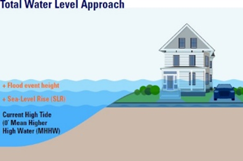
Total Water Levels Tool
First time users, please use the interactive tool to determine your Total Water Level
Customize the variables to produce a Total Water Level
Total Water Level: 0 Ft.
Summary Panel
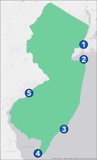
Tide Gauge: Atlantic City, NJ Tide Gauge Total Water Levels Table
Emission Scenario: Moderate emissions
Timeframe: 2030 Planning Horizon
SLR Estimate: At least a 95% Chance of Exceeding - 0.3 ft.
Flood Event: Permanent Inundation - 0 ft. above MHHW
Total Water Level Estimate: 0.3 ft.
Total Water Level Estimated Mapped (nearest ft.): 0 ft.
Emission Scenario Selection
Choose an emissions scenario based on future fossil fuel use and policy decisions.
- High GHG emissions - Corresponds to a future consistent with the strong, continued growth of fossil fuel consumption.
- Moderate GHG emissions - Corresponds to a future consistent with current global policies.
- Low GHG emissions - Corresponds to a future consistent with the global goal of limiting warming to 2°C above early industrial (1850-1900) levels.
Tide Gauge Selection
Choose the nearest tide gauge or the ‘most suitable’ tide gauge based on your own experience and judgement.
Timeframe Selection
Select Planning Horizon
Choose an appropriate planning horizon relevant to your planning task.
2030 to represent a near-term planning horizon for assets that may be short-lived.
2050 to represent longer-term regional planning horizons (e.g., long-range transportation planning) or the life of a current 30-year mortgage. It is also the currently assessed point to which sea-level rise values are “locked in” regardless of whether emissions increase or decrease.
2100 to represent a planning horizon for long-lived assets that will last for decades or investments that need to be designed to adapt to uncertain long-term projections for sea-level rise.
2150 to represent a planning horizon considering multiple future generations and policy decisions through the early part of the next century.
Sea Level Estimate Selection
Less than a 5% Chance of Exceeding
Less than a 17% Chance of Exceeding
Approximately a 50% Chance of Exceeding
At least an 83% Chance of Exceeding
At least a 95% Chance of Exceeding
Moderate emissions
Select a sea level rise estimate based on the level of risk tolerance for your planning project.
Flood Event Height Selection
100-year-flood (1% AEP)
10-year-flood (10% AEP)
2-year-flood (50% AEP)
Annual Flood (99% AEP)
Permanent Inundation
Select a flood event height (Annual Exceedance Probability - AEP), Historic Storm event, or a custom flood event height to add to your selected sea level rise estimate:
Historical Events
New Jersey MyCoast Tool
Climate Snapshot Tool
Please select a county and / or a municipality.
Please Select a Basemap
Legends for Map
Flood Hazard Overlays
Save / Share / Print
Save / Share
Permalink
Create a permanent link of your current map for sharing
Temporary Map Url
Use this link if you’re not ready to make your options a permanent link.


 2021 Updates to the NJFloodMapper include: